 |
Why
Not Look for
A-Tlan-Tis in Mexico? |
Page 1 of 2 -- Next >>
�The Language of a Mighty People is the Greatest History.�
(Edward Pococke; India in Greece.)
�Everyone on Earth Had the Same Language and the Same Words.�
(Genesis 10:1.)
�1. Let it be granted that the names given to mountains,
rivers and towns, have some meaning. 2. Let it be granted that the language of
the name givers expressed that meaning. 3. Let it be granted that the language
of the name givers will explain that meaning.� (Edward Pococke; India in
Greece.)
If Edward Pococke�s above three propositions are valid, then we can come to
only two conclusions in this book: Atlantis existed - in Mexico! And India is
the mother of both.
Of all the frequently told myths and legends on earth,
the one about ancient Atlantis has never ceased to be popular. More than 25,000
books, plus countless other articles have been written about this fabled
confederation of city-states. Yet, speculation continues, especially as to where
it was located. Every place on earth has become a candidate. One article I
recently read on a certain website states that Atlantis existed on some planet
in Outer Space. Another assures us that it existed only as a particular
dimension of human awareness.
In Timaeus (24), Plato pinpointed the location of
Atlantis so clearly that I, at least, am amazed that anyone would think that it
is any place other than the Americas:
This power came out of the Atlantic Ocean, for in those days
the Atlantic was navigable; and there was an island situated in front of the
straits which are by you called the Pillars of Heracles; the island was larger
than Libya and Asia put together, and was the way to other islands, and from
these you might pass to the whole of the opposite continent which surrounded
the true ocean; for this sea which is within the Straits of Heracles is only a
harbour, having a narrow entrance, but that other is a real sea, and the
surrounding land may be most truly called a boundless continent.
Now in this island of Atlantis there was a great and
wonderful empire which had rule over the whole island and several others, and
over parts of the continent�
�there occurred violent earthquakes and floods; and
in a single day and night of misfortune�the island of Atlantis�disappeared
in the depths of the sea. For which reason the sea in those parts is
impassable and impenetrable�and this was caused by the subsidence of the
island.
Libya was the Greek name for the whole of Africa.
Both Americas are greater in size than Africa and Asia combined. In olden times,
ships could sail from and to these two continents safely because the whole area
was lined with a number of large and small islands between Europe and America. A
ship was probably never over a day�s distance from land. After the death of
Atlantis, the ancients (that is, everybody except the Phoenicians) had to cross
the Pacific Ocean, which also had numerous islands and safe harbors, to reach
what are now Meso- and South America.
The names that the Incas, Nahuas, and Mayas gave to
sailing vessels indicate that after the Great Flood, the Phoenicians generally
went to the Americas via the Pacific Ocean. A Sampan is a seaworthy
flat-bottomed sailing barge that was once common in China, Japan, India, and the
South Seas. The word is derived from the Sanskrit Sam (Association; Company)
plus Pan (Trade). The South American Indian coastal tribes called it Mayu (Skt:
�Wealthy�) Chimpana. For the Nahuatl speakers it was Chan-Pan (Moving
House). The Mayans used the East Asian version: Sam-Pan (Moving House). The
Sanskrit term for �floating wooden vessel� was Van-Plu, also Va-Plu (�Floating
Transport�). The Hawaiians and other South Pacific islanders� word for �rowboat�
was Wa-Apa; the Incas called it Wam-Pu.
The �boundless continent,� which Plato said
Atlantis controlled, had to be both Americas. As Plato said, the Pacific Ocean
separated Atlantis from other land masses lying westward. East Asia?
Plato explained that the volcanic explosion which
destroyed Atlantis had left a huge, muddy barrier, possibly a swamp, beyond the
Pillars of Hercules (Gibraltar), keeping ships from going farther westward.
Skeptics have used his statements to prove that he had invented the story of
Atlantis. Gradually, over the centuries, this muddy swamp dissipated, worn away
by the movements of the sea and tides. Even now, the 1,300 low-lying islands of
the Maldives, a still visible relic of Atlantis� twin brother Lanka, are being
destroyed in this fashion. Geologists say that by 2050 AD the small nation of
Maldives will have sunk under the sea forevermore, just as Atlantis did.
The huge floating expanse of aquatic salt-water plants
called the Sargasso Sea also could have persuaded many sailors not to venture
farther westward. Until this day authors sometimes write dismal fictional
stories about ships getting tangled in those seaweeds, never to escape.
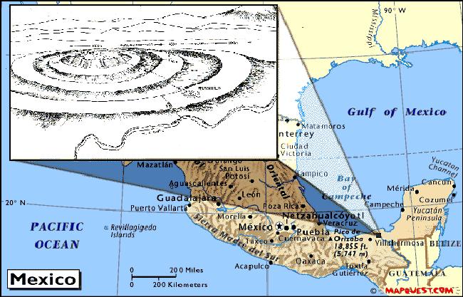
Although Atlantis could have extended far beyond the
regions I discuss in this book, as much as possible I intend to stay well within
the boundaries of the Gulf of Mexico and the Caribbean sea; Plato said that
Atlantis lay just beyond a group of smaller islands which are our present day
Antilles or West Indies. It�s more than possible that Atlantis extended beyond
this region. However, if this riddle is to be solved once and for all time, we
must start on solid foundations, venturing eastward step by step. The existence
of Atlantis can definitely be proven if we slowly move eastward from Mexico�s
eastern shores.
Etchings on Phoenician coins often contain maps of the
whole world. Yes, they even include the Americas! Mark McMenanim, a geologist at
Mount Holyoke College in Massachusetts, believes that the Carthaginians cast
gold coins produced between 350 and 320 BC, depicting maps of the Mediterranean
world with India to the East and America to the West.
When McMenanim enlarged pictures of some of those coins
with his computer, he was amazed to note how the strange markings on them
resembled maps made by Ptolemy, the Greek astronomer and geographer. The maps
show what appears to emphasize the Mediterranean region, with Sardinia as a dot
in the center. The north coast of Africa appears at the bottom. Europe is arched
above the Phoenician homeland and India. The Strait of Gibraltar lies to the
west; after that is the land mass of America. When skeptics see the enlargement
of the coins, they become convinced of the correctness of this geologist�s
opinions.
For reasons we can now easily suspect, the
Carthaginians, who were Phoenicians, made laws forbidding any non-Phoenician
craft to venture beyond the Strait of Gibraltar. Only in the presence of a
Carthaginian government representative could certain individuals venture beyond
the Strait of Gibraltar. Anyone caught challenging Phoenicia�s hegemony over
the Atlantic ocean was put to death. Phoenician ship captains and their crews
were ordered to commit suicide and sink their ships on the open sea, rather than
let others follow their secret trade routes. The Phoenicians also reinforced
non-Phoenicians� superstitions about the potential perils of sailing across
the Atlantic. Today, no one can understand such possessiveness. The Phoenicians,
however, did not see their nationhood in terms of land boundaries, but in terms
of all the oceans, seas and coastlands of the world. With huge warships and
armies of Celtic mercenaries, themselves descendents of Phoenicians, they
defended their right to own those oceans.
The Greek historian Diodorus Seculus said the
Carthaginians possessed a large and rich land far out on the Atlantic ocean.
According to him, the Phoenicians had found it by accident when some ships got
lost off the coast of Africa and were carried to the island by the Atlantic
currents. Diodorus said the Carthaginians would not tell anyone the location of
this island. When the Spaniards invaded the Americas, the natives told them
about a mysterious nation called Cabeiri, somewhere in what is now
Northern Mexico and the American Southwest. The Spanish called it La Gran
Quivira (The Great Quivira).
Plutarch (2 AD) wrote that both the Phoenicians and the
Greeks had visited this island which lay on the west end of the Atlantic. The
Greeks even intermarried with Native-American girls.
Before the eastern part of Mexico (Atlantis) became the
bottom of what are now the Gulf of Mexico and Caribbean sea, the present narrow
strip of swamps and the river Chimalap�n connecting Southern Veracruz
and Oaxaca, the Isthmus of Tehuantepec, was a wide waterway uniting the Gulf of
Mexico with the Pacific. About four thousand years ago, sailing vessels could
and did easily cross from the east coast of Mexico to the Pacific in about two
days. Hundreds of years after Atlantis submerged, Phoenician traders passed
through the Isthmus from both the Pacific and the Atlantic.
From the days of the Spanish conquest, the people of
Mexico have dreamed of widening the Chimalap�n (Sheemala-pahn) river and
others, reconnecting the two coasts. In North Indian languages, Shimal =
�The North;� Pan = �Phoenician; Trade.� Thus, Shimal-Pan =
�The North Phoenician.�
During the 1950s, my lifelong friend Haig Kurdian and I
once crossed part of this wide expanse of water-logged swamp and narrow rivers
on a trip we took to Costa Rica. In those days, it was almost impossible to
cross the Isthmus of Tehuantepec by auto alone. However, the railroad did go to
the Guatemalan border. We had to load Haig�s auto onto a flatcar.
Farther to the south of the Isthmus of Tehuantepec, we
find Panama. Its name also derives from Sanskrit or Kashmiri: Pani
(Phoenician; Trader); Maha (Greater; Great). Pani-Maha = �The
Greater Phoenician.� Evidently, the ancient Phoenicians and Atlanteans
preferred to reach either of the two oceans via the Panama route.
In Nahuatl, Pan or Opan means �traveling
or sailing from one side to another.� However, we must take into account that
the Panis named those waterways; their homes were the great seas and
rivers of the world. Nahuatl Apantlaca = �People who live on the water,�
the same name that the Hindus of India also called them. The Hindu holy books
say, �Pani lives on water.�
The Usumacinta (�Oo-soo-mah-SINT-ah�) River
snakes between the common borders of Mexico and Guatemala. It is Mesoamerica�s
largest and longest river, with a basin of 106,000 square kilometers. The sixth
largest river in Latin America, it represents 30% of Mexico�s fresh water. The
Usumucinta was extremely sacred to the Mayans and was a center of their culture.
Several Mayan archeological sites are located on its banks. Even the word Usumacinta
derives from Sanskrit or Kashmiri. Usuma could have been derived from
either the Sanskrit Zamu or the Kashmiri Shuma, meaning �Peaceful;
Tranquil.� Although the Usumacinta is generally peaceful and meandering, its
color is a brackish brown. Perhaps it received its Sanskrit name for its color: Shom
(Dark-brown).
Cinta (Cin-ta) is readily recognizable as
the Sanskrit Sind, Sinde, or Sint, the ancient Persian word
for �River.� Even in languages like German, Sint means �Sind;
Indus.� Since this word Sint also means �Holy� in many languages, I
am assuming that we derived Saint from Sind. For the Hindus, the
Indus (Sind/Sint) river was and is equal with the Ganges in sacredness and as a
center of Hindu culture.
Several of the largest Amerindian tribes use variations
of the word Hindu, Inde, or Sind in the Americas to
identify themselves spiritually and culturally. I am going to separate each of
these �Hindu� derivations by syllables so that you can more easily notice
the relationship:
The O�odhams of Southern Arizona call their way of life Him-day.
In-de is the real name of the Apaches. In-ti and Hen-di-tre
were Tarascan honorifics for the sun and their leaders. Among all the
Nahuatl-speaking peoples, the honorifics Tzin and Tzin-tli were
used. Un-dey(s) is the Inca word for the Andes Mountains they
worshiped. In-ti Raymi (Hindu Rama) was the Inca Sun God. Many more
tribes used similar derivations of Indus and Sind, but the
European languages and traditions have successfully made them forget their Old
World origins.
These astonishing similarities cover a large part of
both Americas - from the United States Southwest down to and including much of
South America. It is highly unlikely that they are coincidences.
If, as Plato stated, we can still cross the Atlantic
ocean, inevitably reaching a place that all the Indians of Mexico once
called A-tlan-tis, which is what much of Mexico still calls itself, do we need
any other proof? History has proven that until now, everyone has disregarded the
proofs that Plato, Diodorus, Plutarch, Herodotus, and the Phoenician maps have
given us. Will I be an exception to the rule? I have my doubts.
The pre-conquest Meso-Americans claimed that their
primordial founding city was Toll�n. The original name of the Toltec
ruins of Tula, Hidago, on which the Mayan city of Chich�n Itz� was modeled, is
also Toll�n. However, similar place names omitting the �O� exist all
over Mexico: Atl�n, Autl�n, Mazatl�n, Cihuatl�n, Cacatl�n, Tecaltitl�n,
Atitl�n, Zapotl�n, Minititl�n, Ocotl�n, Miahuatl�n, Tecaltitl�n,
Tepatitl�n, Tihuatl�n, Texiutl�n, and the like. Notice that the Nahuatl Tl�n
root of these place names is exactly like the Tlan in �Atlantis.�
Toll�n is just another variety of �Tlan� and the Sanskrit word Talan.
The �n� part of both the Mexican and Sanskrit equivalents means �People.�
Even in our English language, we do the same thing: America(n); Europe(an);
Mexica(n); Russia(n). In both what were once North India (Southern Russia,
Chinese Turkestan, Afghanistan, Pakistan, etc.) and Meso-America, the �n�
suffix was often omitted, especially if the name of the place ended in Tal/Tala.
In Mexico we find places like Tlaxcala; Mixquiahuala; Sinaloa; Guatemala;
Cosal�; Ayutla; Mitla; Tonal�; Chapala; etc. Similar endings, from
Southern Russia down to Pakistan, are Nepal; Coushala; Sinhala; Bhopal; Tal;
Shawl; Kabul; etc.
Besides the Tl�n root, other Meso-America place
names end in T�n and An: Yucat�n; Juchit�n; Champot�n;
Celest�n; Comit�n; Tehuant�n; Rost�n; Mexcaltit�n; Tehuant�n, etc. The
regions from Southern Russia down to Pakistan, once part of India, also have
place names ending in Tan and An: Afgh |